


How we built a sensor network to guide decision-making
How hot? How wet? How windy?

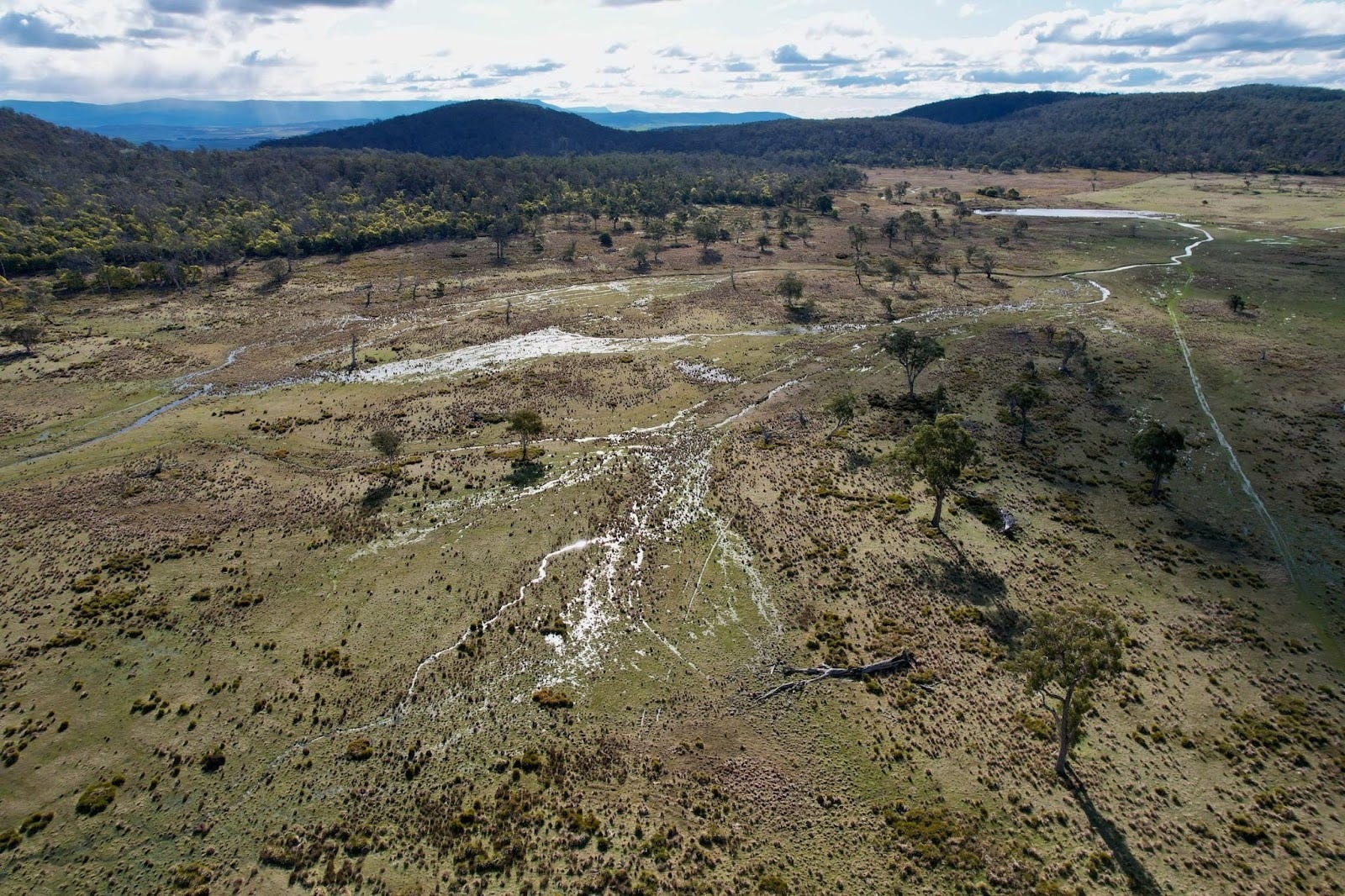
The Quoin is just under 50 square kilometres in area: the Quoin cliffs and plateau, after which the property is named, sit in the middle and roughly divide the property into two halves, with the basin of Stocker’s Bottom in the north, and Honeysuckle homestead and Tinamirakuna/the Macquarie River in the south. Densely forested hills and deep valleys bracket the dolerite plateau to east and west: further south the ground becomes rockier, the forest drier and more open. Most of the land is more or less intact bush, but around one-tenth of the total area was cleared for agriculture in the twentieth century, mainly for sheep but also some cropping.
Five thousand hectares is a lot of land to cover, and there are parts we haven’t stood in yet. The terrain makes it slow to get around, slow to know: how are things going in this landscape? What’s the temperature? What about the humidity? Has it rained? How much? How moist is the soil? How windy is it? From what direction? How likely is a bushfire?
We use a sensor network to answer these questions, to be places we can’t, to learn the rhythms and patterns of the landscape and help us make good decisions.
Rain gauges and thermometers aren’t new. People have been measuring nature with increasing precision for thousands of years. But those traditional ways of measuring all had two limitations: they had no memory of their own, and they couldn’t be read long-distance, so people had to go to the instruments to take measurements and record them.
A modern sensor network overcomes these limitations. Instead of us checking a rain gauge every morning, or a thermometer every hour, we get data every 15 minutes, day and night. And we don’t have to drive, walk or sometimes climb to get those measurements: they’re collected for us in one place for storage and analysis.
We currently have six pairs of sensors permanently in the field:
In three locations, we pair a weather station with a soil moisture sensor; and
In three locations, a combined temperature/humidity/CO2 sensor is paired with a fuel moisture sensor.
Pairing the sensors lets us correlate the measurements between devices and understand the context of those measurements. How does local rainfall affect soil moisture? How do temperature and humidity correlate with fuel flammability?
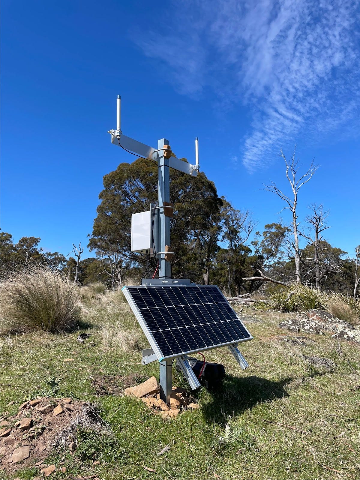
Weather stations and soil moisture
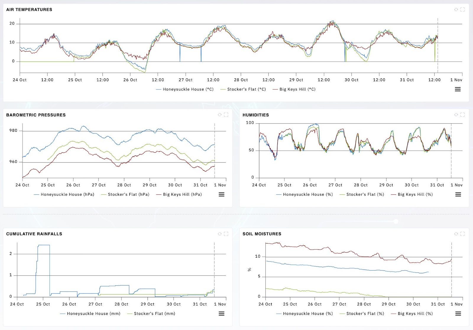
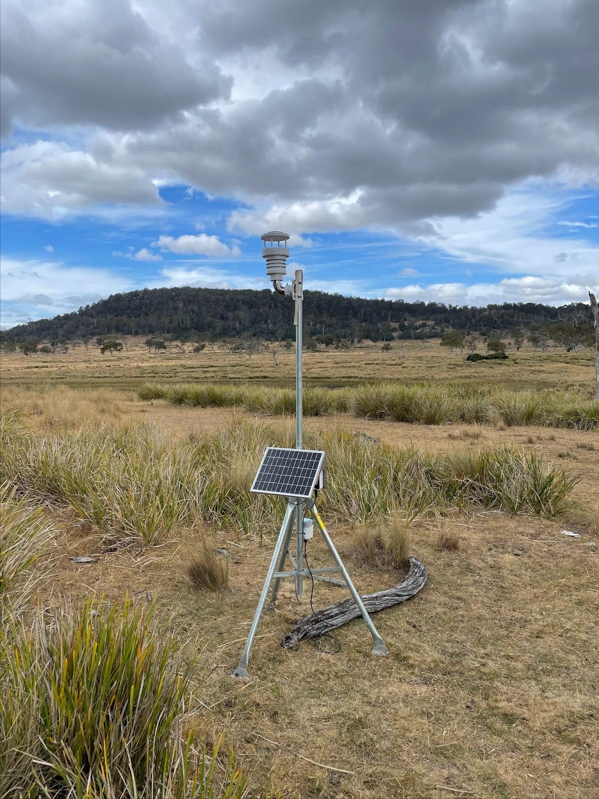
We have two identical weather stations in the two main areas where we’re planning restoration plantings on previously modified pasture, and a third, older weather station on top of one of our more prominent hills, where it can bear the brunt of the Roaring Forties. They record air temperature, humidity, pressure, rainfall, wind speed and wind direction.
Each station is paired with a soil-moisture sensor, letting us see how rainfall events affect local soil moisture, and how fast the soil dries out, correlated with temperature and wind.
One thing we’ve noticed is how sensitive soil moisture sensors are to their exact location and the soil they’re in: when we moved a weather station just eight flat metres, the moisture as measured in the soil dropped by 11% – clearly a very different soil microclimate.
One use of the weather stations is to assess feasibility for field activities. Cultural, ecological and weed-control burns are hard to get up when vegetation is too wet, and some roads are impassable after significant rain. Having a near-real-time understanding of conditions is a big help for planning.
At a longer time scale, understanding the local climate can help us make smart choices about how we regenerate the landscape. Is this area better planted with Eucalyptus pauciflora, or will Eucalyptus ovata fare better in wetter soil? How much rain does it take to keep this dam full, in case we need to draw on it?
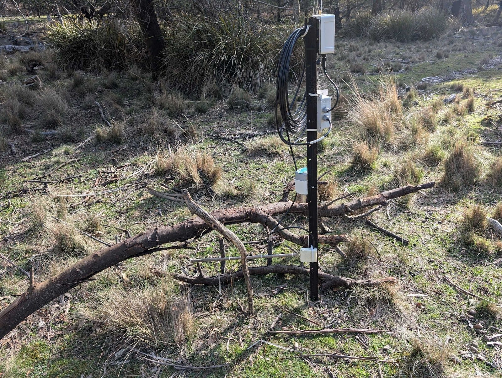
Bushfire sensors: Temperature, humidity, CO2 and fuel dryness
We have three paired sensors for bushfire awareness. One sensor monitors air temperature, humidity, and carbon dioxide, and the other is a fuel dryness sensor typically used in forestry operations, which uses a standardised wooden dowel with a metallic strip that measures conductivity and hence moisture in the wood.
We’re using these sensor pairs, along with our weather and wind data, to do two things: firstly to estimate the likelihood of fire conditions, and secondly to tell us if there actually is a fire in the area.
Fire will always be part of the rhythms of the Australian bush, so it’s important for us to understand our exposure and plan our activities accordingly – we don’t want to risk fires from hot machinery or sparks flying. A hot, dry, windy day with dry fuel is a recipe for bushfire: when the danger is too great, we play it safe.
One metric we’re synthesising is vapour pressure deficit, which is a measure of the gap between how much moisture the air could be holding given temperature and humidity, and what it actually is holding. It’s a key indicator of bushfire propensity. Correlating that with longer-term weather trends can give us an understanding of how our bushfire risk is evolving.
As for detecting active fire, we had hoped that CO2 as a combustion byproduct would be a useful proxy for nearby bushfire activity, but it turns out that our noses are much more sensitive: even quite a strong smoke presence has limited effect on measured CO2 concentration. What does increase measured levels is a still, quiet night: CO2 is heavier than air, and it sinks down into the valleys when the wind drops.
In the future we’ll be exploring PM2.5 sensors, which detect small smoke particles: on the one hand, smoke will only be detectable if the wind is in the right direction: on the other hand, a bushfire is more of a problem when the wind is blowing it towards you. There are also more exotic options, including AI-enabled cameras which scan the horizon for smoke (alas, currently quite expensive and power-hungry).
Keeping them working and connected
The perfect sensor is small, cheap, robust and reliable: in the real world we need to keep the network operational in a sometimes unforgiving environment. We’ve had curious devils chew on wires; rainfall measurements gone awry because the funnel got filled with bird poo and algae; and fuel-moisture sensors knocked over by animals. Once we had to move a weather station because the batteries went flat — the acacia immediately north had grown tall enough that the winter sun couldn’t reach the solar panels. It makes sense to keep our sensor network small and simple so we’re not constantly checking and fixing equipment.
Each device records measurements, generally at 15-minute intervals, and it sends that data via wireless connection to one of the gateways we have on the property. From there, the gateways relay that information via 4G mobile network to the internet, where they’re made available to us as a series of configurable dashboards. We partnered with Tasmanian company Indicium Dynamics for specification, installation and rollout of the network, and they maintain the devices, data store and dashboards. Most of the devices we’re currently using are built by Milesight.
The wireless network protocol our sensor network uses is LoRaWAN: Long Range Wide Area Network. It’s like the wireless network you might have in your home or office, but with lower bandwidth, longer distances, and better penetration through obstructions. Sensor measurements are very lightweight (like sending a text message rather than a phone or video call) so devices can be small, with low power needs. Many will last years on a set of batteries, others have small solar panels.
Our main challenge is line-of-sight for communications. The Quoin has many hills and valleys and a giant lump of dolerite in the centre, so we’re limited as to the locations where we can put a sensor, which can see a gateway, that can get 4G mobile coverage.
There are parts of the Quoin we can’t get to yet with our current setup.
As time goes on, we’re exploring new opportunities for connectivity: older mobile networks are being converted for narrowband Internet of Things (NB-IoT), which has broader coverage (with lower bandwidth) than newer networks, and direct-to-satellite communications are starting to become cost-effective.
The future for our sensor network
The laws of physics will always force us to make tradeoffs between bandwidth, power usage and broadcast distance, but as technology improves, opportunities emerge. Over time we’ll augment our sensors with more capabilities, things like water levels and flow, flagging whether cat-traps have been triggered, and perhaps more advanced techniques using on-device intelligence to identify species and take appropriate action. Can we detect when hungry deer are approaching restoration plantings and scare them off? Could we build traps which catch cats but let quolls and devils go?
With each advancement, our sensor network improves our understanding of the landscape and informs our on-the-ground efforts to support the ecosystems we’re striving to conserve and restore.
This article was written by: Michael Honey
And edited by: Andrew Wenzel, Bronte McHenry, Karina West and Lisa Miller
Love it! Thanks for the share Michael and awesome work as always!
I've been playing with LoRaWAN a bit, thinking about setting up some data collection on a seaweed farm... haven't gotten further than a microcontroller on my desk yet but you've inspired me.
I wonder if you could get a network of daisy chained Lora gateways to extend the coverage between web connected gateways.